Recent satellite data from the U.S. Space agency NASA indicate that sea ice in the Arctic and Greenland is melting at a faster rate than previously projected. VOA's Paul Sisco has the story.
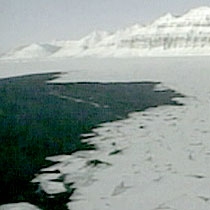 |
| Arctic melting |
Climate scientists at NASA's Goddard Space Flight Center in Greenbelt, Maryland, outside Washington, say the Arctic Ocean could be mostly ice free in late summer 2013.
"The sea ice is decreasing faster than all the models predicted," says Jay Zwally, the ice satellite project scientist at NASA Goddard, "We not only have the warming of the atmosphere, we have a warming of the ocean that is affecting this. It has been surprising to everybody, this decrease in area. This is a marked departure, and this is suggesting to us that maybe we are getting at this tipping point."
 |
| Jay Zwally |
"If you push something like a glass to a certain point, and leave go, it will come back; but if you push it too far, past a tipping point, then it is gone," he explains. "Now what is happening in the Arctic Ocean is the sea ice is getting thinner; it is decreasing in area. This opens up the ocean to more heating from the sun, so it is very likely that the Arctic Sea ice is now at this tipping point, where even if the climate doesn't warm any more, stays as it is, most of the sea ice will decrease and disappear at the end of the summer."
"Up through 2006, in September we've been losing ice at the rate of a little more than nine percent per decade,” says Mark Serreze, a senior researcher at the U.S. National Snow and Ice Data Center in Colorado. “That's equivalent to about 100,000 square kilometers per year, which is quite a bit. What's happened in 2007 has just sent an exclamation point to this."
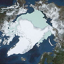 |
| NASA satellite image shows Arctic over the last 30 years |
This satellite image from NASA shows the average sea ice in the Arctic over the last 30 years. The green area indicates the melt at the end of last summer.
Zwally says there is clear indication that the remaining is thinning. "The key thing is that this area that is remaining is now thinner," he said. "There used to be a lot of ice here that was three- four, five, six meters thick, and most of that is gone."
All climate models have variability and the possibility that melting trends may lead to results less severe than predicted.
"The other possibility is that it could be worse than the models predict and this is an example, a specific example of the sea ice in the Arctic where what is happening, what we see with the satellite is actually worse than the models predicted," he adds, and he says those models are supported by ground based observations and measurements.
source:
www.voanews.com


 E-mail this to a Friend
 Print
Print


 suprememastertv.com